Showing posts with label FEMA. Show all posts

Monday, February 6, 2012

Schultz and Summers Engineering & Surveying Highlights Their FEMA Flood Surveys

Almost up


We just added some billboards to our advertising plan in Branson.  Because of the new flood maps many homeowners find themselves in a FEMA flood zone.  These billboards highlight our surveying services and how we have helped hundreds of customers save thousands of dollars on flood insurance. 

This one is done

Wednesday, January 4, 2012

The Joplin Field of Dreams

This is a short video with Melinda Vaughn, Stan Schultz, Charlie Bass ,Shawn Bass and Heather Morgan.  They do a great job of explaining how FEMA and the USACE worked together to rebuild Joplin's ball fields.  C&M Contractors was the project manager and they had Schultz and Summers Engineering do the design work while Ridge Hill Contractors helped with the construction.

This $1 million project was designed by SSE in just 9 days and C&M completed work and had the fields ready for use 45 days ahead of schedule.      


Here are a few photos of the finished fields.


Tuesday, December 20, 2011

OVER 60 ATTEND THE FEMA FLOOD INSURANCE SEMINAR

Realtors, bankers ,insurance agents, and floodplain managers attended
the FEMA seminar sponsored by Schultz and Summers Engineering 

Monique Pilch covered Flood Insurance
BRANSON, MO-  SSE hosted an informational flood insurance seminar to help local bankers, realtors, insurance agents, developers, contractors, and homeowners better understand how the Federal Emergency Management Agency (FEMA) determines flood zones and how the flood insurance program works. Over 60 individuals involved with the property transaction process attended the 5 hour seminar.  Bill Watson from Tri-Lakes Reality said, “More and more real estate sales are being impacted because of floodplain and flood insurance issues.  The information presented at the seminar has given me a much better understanding of the process and how I can help my customers correctly deal with these issues.  I also own property in Iowa and the flooding up there was terrible.  This seminar really helped me better understand how the process works.”

Scott Samuels, the former Floodplain Management Engineer for the State of Missouri Emergency Management Agency (SEMA), and Monique Pilch, the current FEMA RVII Insurance Representative, were the main instructors for the day.  Scott presented a program covering Floodplain basics: NFIP background, why FIRM's are updated, and what to do when you are in a Special Flood Hazard Area (SFHA). They also went over Elevation Certifications and the LOMA processes.  Monique focused her time on Flood Insurance Rate Maps and how to understand the effects of map changes on flood insurance, as well as working through the claims processing after a flood.  “Teaching in a seminar like this is a great way to help the public better understand the FEMA flood management process and how the insurance program works.  The Branson participants were very engaged and asked some great questions.  With all the flooding that has taken place here I very much enjoyed helping them better understand and participate in the program, commented Monique.”     Rodney Jetton from SSE concluded the session with a summary of their surveying services, prices, and how they help homeowners obtain a LOMA.

Sixty-eight counties in Missouri either just adopted new maps or will be adopting new FEMA flood maps, including Taney, Stone, Christian, Lawrence, Barry, and Green counties in southwest Missouri.  These map updates place some properties in the floodplain while others may be removed.  Once a property is in the floodplain flood insurance can be required.  Ron Tagge, owner of Ron Tagge Insurance added, “Lenders are now  federally required to determine if a property is in a floodplain.  If there are any doubts homeowners are being forced to buy flood insurance.  I’m dealing with more and more of these situations, but if the homeowner has a survey done and proves they are above the floodplain they can eliminate or reduce the cost of the insurance.  We do everything we can to make sure a homeowner has the required coverage, but if they do not need it we can help them get the help they need to show FEMA and their banker exactly where their house is in relation to the floodplain.”


Scott Samuels explains how maps are updated
Most communities where new maps have been adopted report having new properties end up in the flood zone while some properties are removed.  This forces those new property owners to obtain flood insurance.  Sometimes properties that have never flooded and are clearly out of the floodplain are shown by the new map to be in the floodplain.  Instructor Scott Samuels explained it by saying, “The Flood Insurance Rate Map (FIRM) map updates are designed after careful watershed studies using aerial photos and contour lines.  While these tools are good, they do not perfectly reflect the elevation of a property within the floodplain.  Conducting a survey is the best way to show the exact elevation of a property.”

Wendell Beard looks over a plat map
FEMA recognizes that the maps are not perfect and have developed a process for removing a property from the floodplain.  If a homeowner provides an Elevation Certificate (EC) to FEMA that shows the finished floor of a structure is above the floodplain elevation, FEMA then gives the homeowner a Letter of Map Amendment (LOMA) that can be used to remove the property from the flood zone.  SSE surveyor Wendell Beard mentioned, “I have done hundreds of elevation surveys around our lakes here in southwest Missouri and about 75% of them prove that the structure is not in the floodplain.  I know it’s a hassle for the folks who have to deal with it, but helping homeowners determine if they are in the floodplain is a part of my job I very much enjoy.”

Schultz and Summers Engineering has developed a program that lowers the costs and speeds up the process of getting a survey done and applying for a LOMA to FEMA.  Their program has kept them very busy and they report doing over 650 flood elevation surveys in 2011.  Business Development Director Rodney Jetton added, “Our flood survey business has exploded because we charge a low standard fee, offer neighborhood pricing discounts, guarantee a quick turnaround time and even offer a minimal trip charge if the survey shows you are in the flood plain.” 
Participants learned a lot about floodplain liability
       

Friday, December 2, 2011

KOLR10- FEMA Sorts Out Insurance Impacts from Spring Flooding

Here is a story on the FEMA flood insurance class Schultz and Summers sponsored. Over 60 bankers, realtors and floodplain manager attended the classes.

SSE has completed over 650 flood surveys in Missouri this year. Their low set fees, neighborhood pricing discounts and minimal trip charges for those who are in the flood zone have been a big reason so many people have had them help them with their surveys.

Another aspect of their service that is bringing them more business is that they do all the paperwork and work with FEMA to get the property owner a LOMA. They also guarantee to finish flood surveys in one week.


http://ozarksfirst.com/fulltext?nxd_id=564947

Monique Pilch the FEMA flood insurance specialist explain the claims process


Thursday, December 1, 2011

KSMU- Engineering Firm Offers Help Understanding New FEMA Flood Maps | KSMU

Missy Shelton of KSMU talked with Stan Schultz about the upcoming FEMA class in Branson. We have helped hundreds of homeowners save thousands of dollars but surveying their property and proving that they are not in the Floodplain.


Engineering Firm Offers Help Understanding New FEMA Flood Maps | KSMU

Listen to the story here-
http://ksmu.org/media/mp3/engineering-firm-offers-help-understanding-new-fema-flood-maps_26368.mp3

Wednesday, September 14, 2011

SAVING MONEY ON FEMA FLOOD INSURANCE


SSE is saving residents money by offering:


Neighborhood pricing discounts
Minimal trip charges
Quick turnaround times 


LAKE OZARK MO- More and more residents in the Lake of the Ozarks region and all over Missouri are being required to prove that their home is not in a flood plain.  Many have lived in their homes for several years with no flooding problem but because the Federal Emergency Management Agency, or FEMA updated the lake area flood maps last year; residents are being required by insurers, lenders and FEMA to prove that they are not in the flood plain. 

Here is a sample FIRM map
          FEMA occasionally changes the floodplain boundaries because of things such as population growth or decline, levee changes, and infrastructure improvements.  Also better technology allowing for better mapping can change a FEMA map.  These changes can move a property owner previously out of the floodplain smack into the floodplain.   This is the case for many residents of Camden County, Missouri.  Planning Administrator, Chris Hall said, “Some portions of the lake have had their BFE (Base Flood Elevation) level increased and those areas are adversely affected by these changes.”

          This has caused the most trouble for lakefront homeowners.  SSE owner Stan Schultz added, “When an insurance provider or a bank views the new maps, they are almost guaranteed to deem lakefront property as part of the floodplain even though the property has never even been close to flooding.”

          Here is an example of how it might work on let’s say Mr. Smiths lakefront home.  Mr. Smith was dumbstruck last year when the bank that holds his mortgage sent a letter alerting him that he had to purchase flood insurance for his home on the lake. In 30-plus years, the lake has never has gotten close to the house, and insurance was never required before. But the Federal Emergency Management Agency, or FEMA, updated its flood maps last year, and Mr. Smith’s home was declared at risk of flooding. Not only that, his house went from requiring no insurance to being in the highest possible flood-risk category.

          According to FEMA, the national average for the cost of flood insurance is $600 a year, but Mr. Smith pays $1,100 annually. During the 25-year life of his mortgage, he will have paid close to $30,000 to protect his high-and-dry home from floodwater that would have to be delivered to his house in buckets.

          Mr. Smith said, “If there had been a flood issue, I’d have walked away from this place and not bought it. I wanted nothing to do with a flood. Now I’ve gone from being in a ‘No problem area’ to being in the worst possible classification.” His insurance agent Mr. Jones, said he tried to help Mr. Smith do battle with the government, but the pair got nowhere. “Not only was his house put in a floodplain after all these years, but they put him in the highest category,” Agent Jones said. “Mr. Smith is in the same flood zone as someone who lives directly on the river — Zone A. “He’s probably paying four times more than he would if FEMA put him in Zone B. It seems crazy.

          Many Missourians have dealt with this exact same scenario.  For some it was a nearby lake or an adjacent river and for others it may be an older levee.  For many it’s hard to understand!  Some say the new FEMA maps are merely moneymakers for the federal government, adding it’s almost “impossible” to get a residential floodplain status changed.

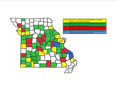
Missouri map showing affected counties
          But the folks at FEMA say that is just not true.  Laurie Smith-Kuypers, Natural Hazards Program Specialist in FEMA’s Chicago office, said “It’s not that big of a deal to ask the agency for reconsideration. All the homeowner has to do is hire a surveyor to produce an elevation certificate, proving his house is not in the floodplain.”

          Hiring a surveyor to come out and check the flood elevation can be expensive, plus there is no guarantee your home will be out of the floodplain.  Schultz and Summers owner Stan Schultz said “SSE developed a special flood certification process to help residents deal with the FEMA map changes.”  He added, “We tried to keep the costs as low as possible.  For a few hundred dollars we will come out and survey the property as well as turn all the paperwork into FEMA so the homeowner will get a Letter of Map Amendment (LOMA) that they can provide their lender or insurer.”  Schultz continued, “Another benefit we offer is the minimal trip charge.  Many times after our surveyors shoot the elevation they can determine if the home is not going to qualify for a LOMA.  We offer all our clients the option of stopping work and paying only a minimal trip charge.”

Add caption
 After visiting with SSE we contacted a few of their customers to see exactly how the service worked.   Philip Houghton from Gravois Mills, MO found out he was going to be required to purchase flood insurance a week before closing on his third floor condominium.  The quote for his insurance was estimated to be $3500.  He was told to purchase the flood insurance or forfeit the sale. 

Mr. Houghton called SSE and asked how much an elevation certificate would cost and could the whole process be completed before his closing.  He said, “I didn’t know if they could do it in time but amazingly they came out, did the survey and had the LOMA in less than 24 hours!”  In this case a homeowner was able to prove that the property was not in the flood zone allowing the lender to close the loan without forcing Mr. Houghton to purchase expensive flood insurance.  Houghton added, “The service I received from SSE was fast, professional, and fairly priced. They not only saved me money they kept my real estate transaction from falling apart.”

Another interesting story showing the difficulties the new FEMA maps have caused concerns.  Randall Carr and Susan Gepford from Stover, MO were tired of paying for flood insurance and hired Schultz and Summers Engineering to do a survey to see about obtaining a LOMA from FEMA and dropping their expensive flood insurance.  Susan said, “The surveyor came right out but unfortunately he informed us that our home was not going to qualify for a LOMA.  They asked us if we wanted to stop the process and pay the $100 trip charge or if we wanted to have them finish it up and see if we would come out in a cheaper flood zone.” She continued, “We told them to go ahead and finish it and even though we were still in the flood plain, our new elevation certificate lowered our flood insurance by $897!!”

          These two stories had happy endings but residents are still upset about all the extra hassle and costs the new FEMA maps have caused.  Smith-Kuypers said “The new maps were produced with the help of better topography, which was supplied by the U.S. Army Corps of Engineers and the U.S. Geological Survey. The maps do not include specific properties but show elevations across each community.”

Stan looking over a flood elevation survey
          Schultz concluded, “While dealing with the map changes is frustrating we are doing everything we can at SSE to provide realtors, lenders, insurers and homeowners with a professional process that can quickly determine if a property is in a floodplain at a very cost effective price.”  He added, “Neighborhood pricing discounts, minimal trip charges and a quick turnaround are just a few of the reasons we are doing more and more flood certifications each year.

Wednesday, March 16, 2011

Lake-area Flood Plain map likely remain unchanged despite FEMA agreement

CityofJackson_pic.jpg

Lake-area flood plain maps will likely remain unchanged despite FEMA agreement - Camdenton, Mo - Serving Missouri's Lake of the Ozarks region including Osage Beach, Camdenton, Lake Ozark, Eldon and Sunrise Beach


Source: lakenewsonline.com

The Federal Emergency Management Agency received some applause and attention for agreeing to re-evaluate its flood plain mapping program, but there probably won’t be much of an impact on flood insurance buying procedures at Lake of the Ozarks.

FEMA altered its approach to evaluating the National Flood Insurance Program midstream, but it will not likely redo its flood plain mapping of the Lake of the Ozarks, specifically the Big Niangua in Camden County, which drew concern and protests from residents a year ago. Read more at: Lakenewsonline.com